Landslides In The Canal

image

Culebra Cut

A few weeks ago, when we were driving to one of our dig sites, we noticed a dip in the road that hadn’t been there the previous week. When we returned to the site the next week the dip was lower by at least six inches. The following week I decided driving down that road was not in our best interest but we wanted to investigate. We were able to document cracks and fissures that were several feet long and 4-12 inches wide. The next week there were men surveying the area and the week after that there were excavators and backhoes. I had read about the massive landslides during the construction of the canal and was aware that due to the geology of the area they are an ongoing problem. It was fascinating and I have to admit a bit disconcerting to watch the progression of the landslide and the remedial measures that were taken in response. I was so intrigued I did a little bit of research.


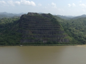
Landslides have always been a problem in the Panama Canal, most notably in the 13-km long section at the southern end of the canal known as the Culebra Cut (also known as Gaillard Cut). The special wonder of the canal is Culebra Cut. It cuts through the continental divide and is the high, hard rock basaltic slopes and the lower, soft shale/clay slopes of the Cucaracha and Culebra Formations that can be seen in picturesque photos of the canal. All the rain and humidity softens the shale into mud and clay. The instability of the mud and clay results in continual landslides. David McCullough in “Path Between The Seas”, his famous book about the building of the Panama Canal, states that all technical problems were small compared to the slides in the cut. Workers on the canal would arrive in the morning and months of digging, as well as equipment, would be completely wiped out by thousands of cubic yards of dirt and rock from slides. The massive slides in the cut also played a big part in the French Canal Company’s inability to complete the canal.
In 1915 the second year of operation, the canal was hit with two major landslides that struck simultaneously. Both the east side and west side of the Culebra Formation slid, resulting in the closure of the canal for seven months. In 1986 a geotechnical advisory board was formed after a major reactivation of the East Cucaracha slide encroached into the navigational channel of the canal and caused a closure of twelve hours.
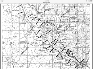
In 1988 a report was issued by Luis D. Alfaro on the risk of landslides in Gaillard Cut. He researched all of the slide events that were documented up to 1986, thirty-one in all. In his report he suggests dividing the cut into zones of relative uniform geological environments to help monitor and document movement. We use these zone names at our dig sites. Today the slopes are monitored constantly through instrumentation and field inspections so remedial measures can be implemented if movement is detected.
image

Culebra Cut

The good news for us is that there is now a newly scraped-clean excavation site for us to investigate for fossils. We went there twice last week and discovered shark teeth, croc teeth, and a bunch of invertebrate fossils. image
Exploring the Panama Canal

Hello from the Panama Canal!

I’ve been in Panama for a little less than two months, but every day we head to the field seems like a new adventure uncovering fossils. We usually head out to the field early in the morning, choose a locality, prospect the area, and we dig until lunch. This past week, however, we deviated from our normal routine to scope out some of the new cuts being made along the Canal, and to see if any looked like promising fossil-bearing localities.

IMG_20151118_100911_172

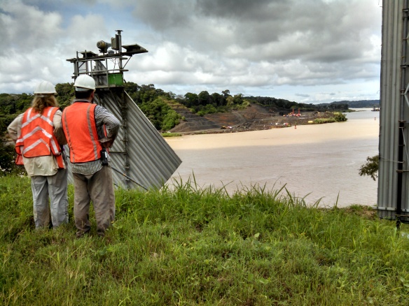
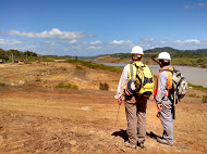
Paris Morgan (left) and Jorge Moreno (right) looking from the east side of the Canal across to the new cuts.

IMG_20151118_100933_268

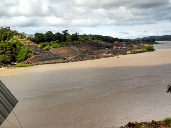
Close up on the freshly exposed rocks on the west side of the Canal.

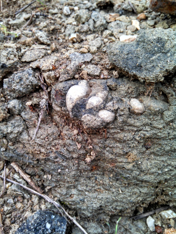
We explored both sides of the Canal for outcrops, and ended up finding several potential localities based on their lithology. My personal favorite was an invertebrate site full of gastropods, bivalves, oysters, and even small nummulites!

IMG_20151117_084454_802

Gastropods found at one of the new localities.

We plan on adding these new sites to our PCP-PIRE database, along with each one’s formation, rock type, and a description of the fossils one can find. Hopefully they will yield new fossils that will augment our understanding of Panama’s paleoenvironment!

-Dipa Desai

Gatún and Empire with the Invertebrate Crew

This trip to Panama has been a little different than normal – we have a group predominantly composed of invertebrate paleontologists and paleobotanists, but have few vertebrate paleontologists. Where do you go in Panama if you want to find invertebrate fossils? Well, you can’t go wrong with the Gatún Formation, which has enchanted malacologists (mollusc-workers) for over a century.

Panoramic photo of the San Judas locality, near the town of Sabanitas in Panama.

Panoramic photo of the San Judas locality, near the town of Sabanitas in Panama. Photo by C. Robins.

We headed to Gatún on Thursday. It was an incredibly muddy day, with thunder often rumbling in the background, but we were lucky to have a wonderful collecting day. We ended up with over 1,000 invertebrate fossils; mostly molluscs, but with a few decapods, too.

Post doc Adiël Klompmaker keeps his paleo-paper easily accessible for fossil-wrapping. Photo by C. Robins.

Post doc Adiël Klompmaker keeps his paleo-paper easily accessible for fossil-wrapping. Photo by C. Robins.

Turritellid gastropods dominate some areas of the Gatún.

Turritellid gastropods dominate some areas of the Gatún.

We tried out multiple localities within the Sabanitas area, but found many had become overgrown and inaccessible in the last few years. This is a constant issue in Panama, where the erosion rate is high and the plants are constantly reclaiming the open space.

We have Prof. Jon Hendricks with us on this trip. He is a specialist in cone shells, and has been working on their phylogeny. He uses UV light to see their color patterns, which have long-since vanished from our visible color palette. We managed to collect around 500 cone snails for him, which was about half of the day’s total haul! (That’s not a true representative of Gatún diversity.)

Dr. Jon Hendricks sorting his fossil cones after a long day in the field.

Dr. Jon Hendricks sorting his fossil cones after a long day in the field.

After a productive day in Gatún, today we stayed in the canal zone. We were able to access the Empire Locality, a locality full of decapods that had previously been within the construction zone, and thus inaccessible to collecting.

Collecting in the Panama Canal - the crabs are too good to pay attention to the scenery!

Collecting in the Panama Canal – the crabs are too good to pay attention to the scenery!

IMG_2469 (1)

Roger Portell and Adiël Klompmaker hunt for decapods alongside the Panama Canal.

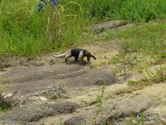
An anteater even tried to help us find fossils. He quickly headed back into the vegetation. Photo by Adiël Klompmaker.

An anteater even tried to help us find fossils. He quickly headed back into the vegetation. Photo by Adiël Klompmaker.

Friday proved to be an incredibly hot day, and we almost welcomed the torrential downpour that arrived around 1PM. The excessive lightning, however, forced us in for an early end. Tomorrow (Saturday) is our final field day, which we will spend as a divided group – part of the group will hunt for crabs, and the museum interns will finally get a chance to test their vertebrate paleontology skills at a few canal sites!

Invertebrate Paleontology in the mid-Miocene: A trip to Lago Alajuela

A visit to Panama City by paleontologists Cristina Robins and Ian Cannon from the University of Florida this past week meant several field days focused on sampling invertebrate fossils. The goal: to obtain a better picture of the diversity of invertebrate communities within the formations in the Panama Canal, and increase collections of crustaceans and mollusks to be studied back at the University of Florida. Most exciting was our visit to a site outside the boundary of the Canal Excavation, to sample from the Alajuela Formation. Pictured below, Lago Alajuela, a man-made lake created along the Chagres River and major reservoir within the Canal watershed.
Invertebrate Paleo. collection team, July 15, 2015. Starting with the back row and moving left to right, Cristina Robins, project coordinator PCP-PIRE; Michael Ziegler, PCP-PIRE Intern; Ian Cannon, University of Florida; Jorge Moreno, PCP-PIRE Field Leader; Gina Roberti, PCP-PIRE Intern, Summer 2015.

Invertebrate Paleo. collection team, July 15, 2015, Lago Alajuela. The terraced shorelines and extremely low lake levels reflect record lows in rainfall during June, the third driest June on record in Panama in the last 100 years. So much exposed shoreline makes for fantastic fossil hunting. Starting with the back row and moving left to right, Cristina Robins, project coordinator PCP-PIRE; Michael Ziegler, PCP-PIRE Intern; Ian Cannon, University of Florida; Jorge Moreno, PCP-PIRE Field Leader; Gina Roberti, PCP-PIRE Intern, Summer 2015.

Continue reading

Bedrock Quest: Reflections on Fieldwork in the Azuero Peninsula

Delicate and intricate, the complexity of ecology and climate in the tropics presents a challenge for any scientist wishing to study more closely patterns of the naturaleza. Especially for geologists, accessing the bedrock, the layer of rock that forms the base of the land–underlying all soil and bodies of water–, is especially tricky. Hot and humid weather year round in tropical latitudes makes for incredible biological productivity, and happy microbes break down rocks into soils at a startling pace. Thus, to find exposures of rock outcrops that were fresh enough to determine the lithology, or composition, required a bit of effort.

A group of students from the University of the Andes examining an outcrop of basalt in Rio Verdadero.

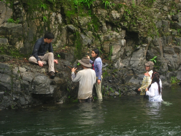
A group of students from the University of the Andes discuss the orientation and lithology of an outcrop of basalt in Rio Verdadero. Plant growth in the rock’s cracks (fractures and faults) highlights patterns in the orientations of such features. Noting the primary direction and orientation of fractures can give information about regional stresses and tectonic changes.

Continue reading

Update on BioMuseo Adventures

IMG_0516

The fruits of Jorge Moreno Bernal‘s labor at Lake Alajuela. Two crocodile teeth, a ray tooth (both bottom-right), and a possible mammalian pelvis or shoulder plate.

In a previous post, Jeremy told us of some of the many exciting things that have been happening in the field as of late.  Lake Alajuela is proven to be not only a very beautiful field site, but fruitful as well; we hope to continue prospecting and discovering there!  In this post, however, I want to talk a little bit more about our work outside the field.

We only have about three weeks left in Panama, and there are many things that we still want to get done.  Creating a narrative for the BioMuseo is one of our main priorities, and there is still much to do.  As promised, today I will give an update on how things are going with our work with the BioMuseo. Continue reading

Smithsonian’s Panama Debate Fueled by Zircon Dating | Newsdesk

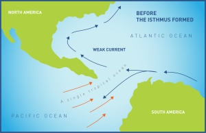
Ocean currents before the formation of the Isthmus of Panama. Photo Smithsonian Tropical Research Institute

Ocean currents before the formation of the Isthmus of Panama. (Photo © Smithsonian Tropical Research Institute)

Camilo Montes and colleagues have made exciting discoveries about the dating of the rise of the Isthmus of Panama using detrital zircons! Visit the following link to the Smithsonian’s website to read the press release! Smithsonian’s Panama Debate Fueled by Zircon Dating | Newsdesk.